Plan Guidance & Regulations
for all Types of Road Projects
GuideSIGN® suite of software products enable you to create, design and plan the installation of traffic signs and pavement markings with the most up-to-date federal & agency standards. Design for roadway, complete street improvements, road dieting, restriping projects and more. Remove the inefficiencies of manual design cycles and ensure compliancy and design with consistency.
Automate the creation of roadway signs with panel styles, text fonts, symbols, and more in minutes.
Create sign groupings, view road layouts in 2D and 3D and complete projects with the pavement marking module.
Design traffic signs for roadways and greenways, and other projects using the best of GUIDESIGN & SIGMA combined into one.
Platform Compatibility
We strive to keep our products compatible with the latest operating systems and platforms. Find the latest product compatibility information for Transoft products.
English
What Makes GuideSIGN Unique
GuideSIGN contains three modules, each with its own features that provide a tailored solution for sign design, sign planning and pavement marking to enhance your workflow.
Create custom signs
With GuideSIGN or PlusSign creation is made easy with built-in rules to design panels to national standards like shields, arrows, text and symbols, with the flexibility to make custom content. Design signs for various needs, such as highways, roundabouts, freeways and more.
Plan and position signs
With GuideSIGN SIGMA or PlusUse signs created from GuideSIGN or from our extensive library to clearly plot, position and visualize your sign plan in 2D or 3D.
Create sign groupings, mount signage on a variety of structures, and use the smart placement to automate the process. Finish off the project with the customizable Annotations and Markers feature to create labels on the sign facing.
Ensure design compliance from the start
With any GuideSIGNCompletely updated to the latest requirements for:
- US (MUTCD 2009 with all supplements)
- Canada (TAC-ATC 2021)
- Australia (AS 1744-2018)
Reporting is a breeze
With any GuideSIGNCreate comprehensive reports outlining all the signage details including schedules or facilitate database schema suitable for importing directly into existing asset management software.
The pavement marking tool automatically calculates and tabulates the quantities of each type of marking on a drawing and even provides an estimate cost, saving you hours over manual calculation methods.
Pavement markings
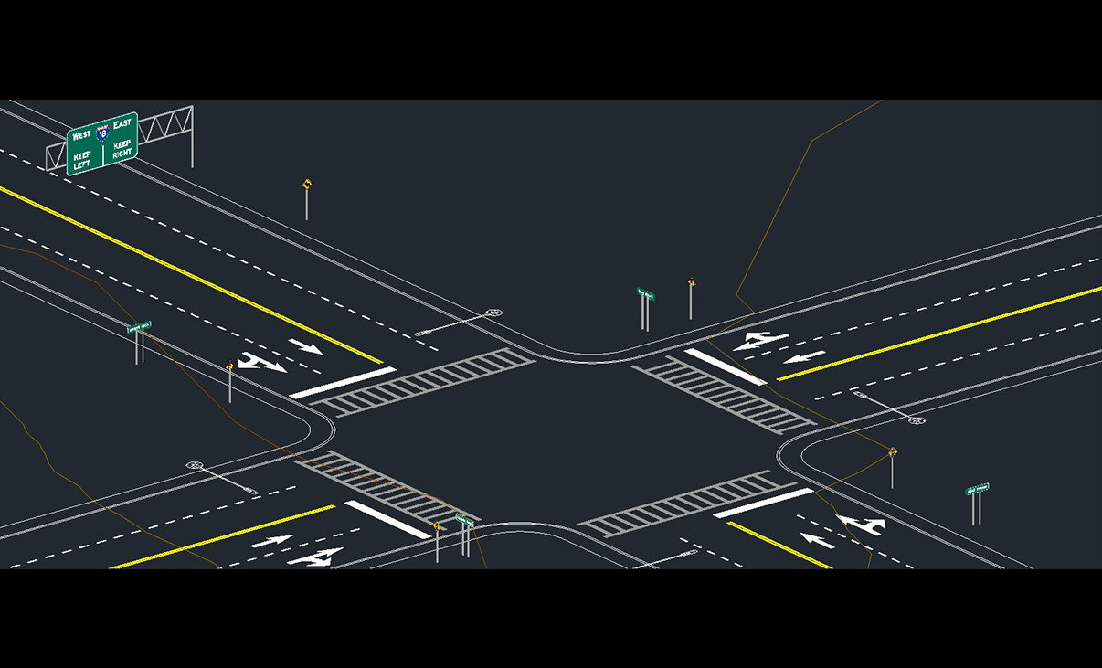
With GuideSIGN SIGMA or PlusDraw a full range of pavement marking objects from rules and manuals – for rural and urban areas, easily adjust and match your road geometry. Items such as dotted lines to crosswalks can be created quickly, and can be edited by grip points and change values to meet any geometry.
Visualize the impact in 3D
With GuideSIGN SIGMA or PlusBring your design one step further to completion – display your signs and pavement markings in 3D to get a better understanding and a realistic view of the impact on your road and intersection environment.
Features
Staying Compliant with Federal & Agency Standards Will Be a Breeze
The GuideSIGN product family is the leading solution for major departments of transportation, regional and local governments, and top consultants. Whether you’re creating plans for highways or construction sites, for complete street improvements or road dieting projects, you can count on GuideSIGN software to create road sign and marking designs with ease.
Equipped with templates and up-to-date guidelines, GuideSIGN products ensure your designs are clear and accurate.
Create Signs
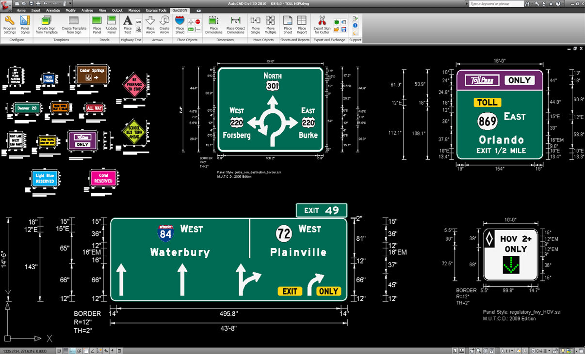
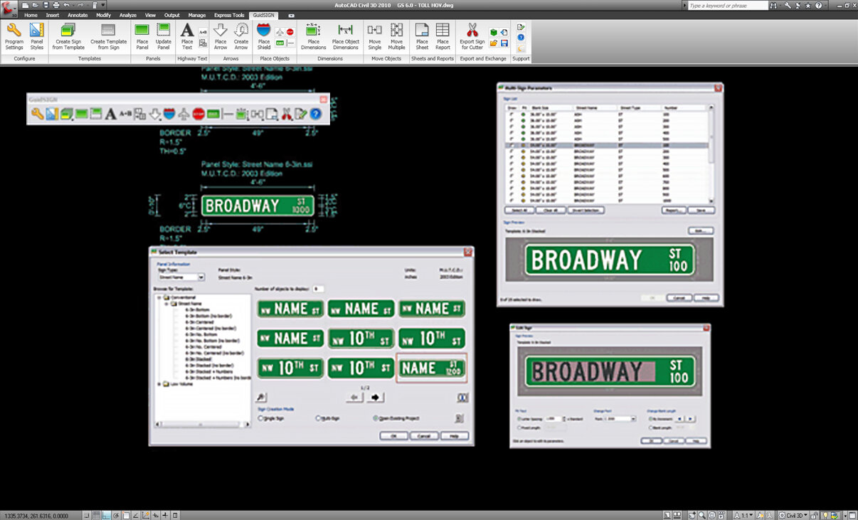
Sign creation made easy with built-in rules to design panels to national standards like shields, arrows, text and symbols, with the flexibility to make custom content. Design signs for various needs, such as highways and roundabouts.
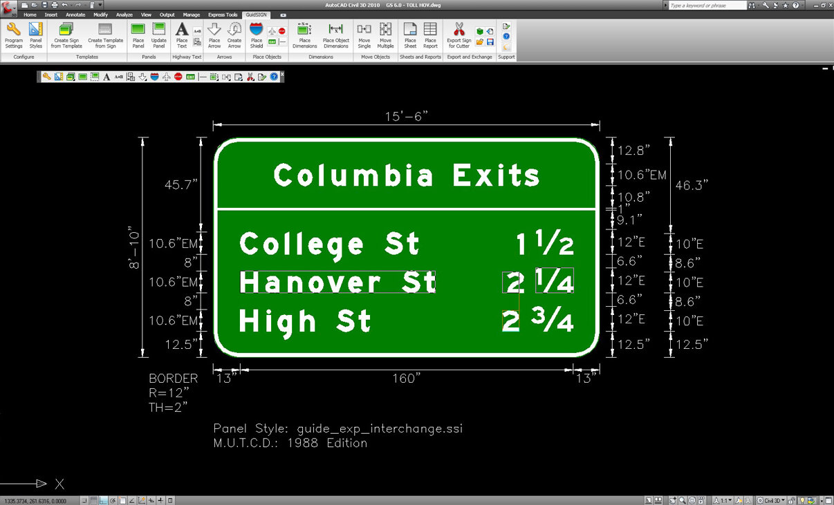
Panel Design
Easy and intuitive panel design. The program automatically re-dimensions dynamic panels as you add new elements. A sign can utilize design symbols from a library including multiple arrows, shields and even custom content.
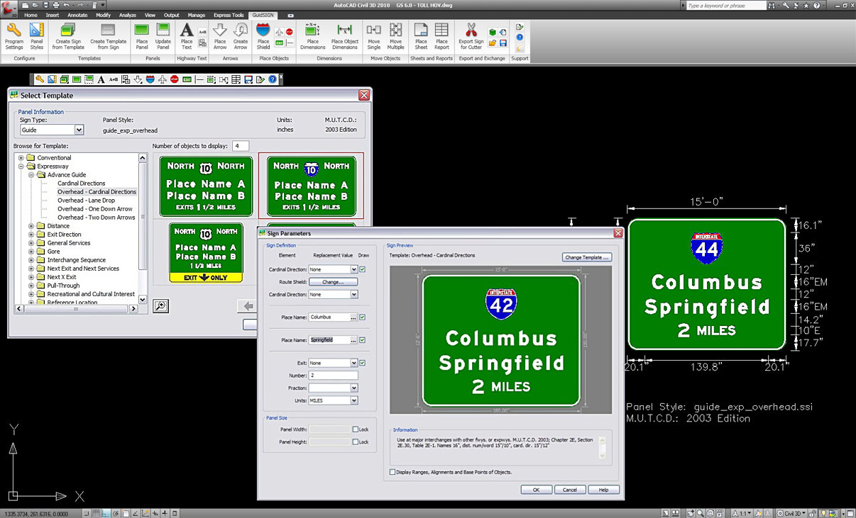
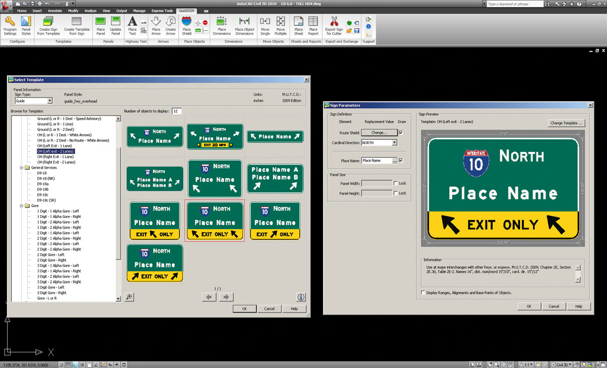
Create Signs From Template or Design Your Own
Design with consistency using guide or street signs from MUTCD standard or design your own custom templates. Create a new sign by simply replacing text and available objects (shields, symbols, etc) within the panel. Together with current US (MUTCD 2009 with all supplements), Canada (TAC-ATC 2001 with updates) and Australia (AS 1744-2018) it provides you with over 200 new sign templates created specifically for the new guidelines.
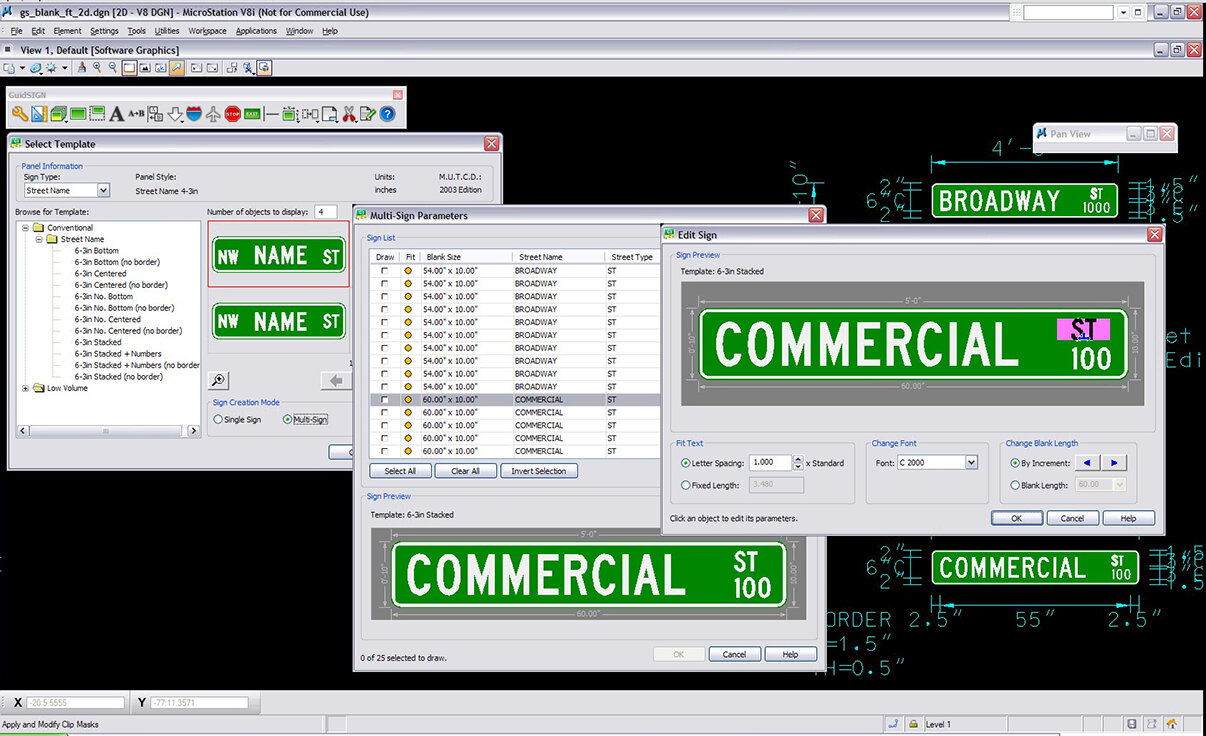
Multiple Street Sign Design
Create multiple street signs in a single operation from a selected template and list of street names, street types, sections of the city, ordinal endings, and block numbers.
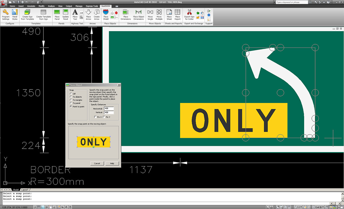
Moving and Placing Objects in Panel
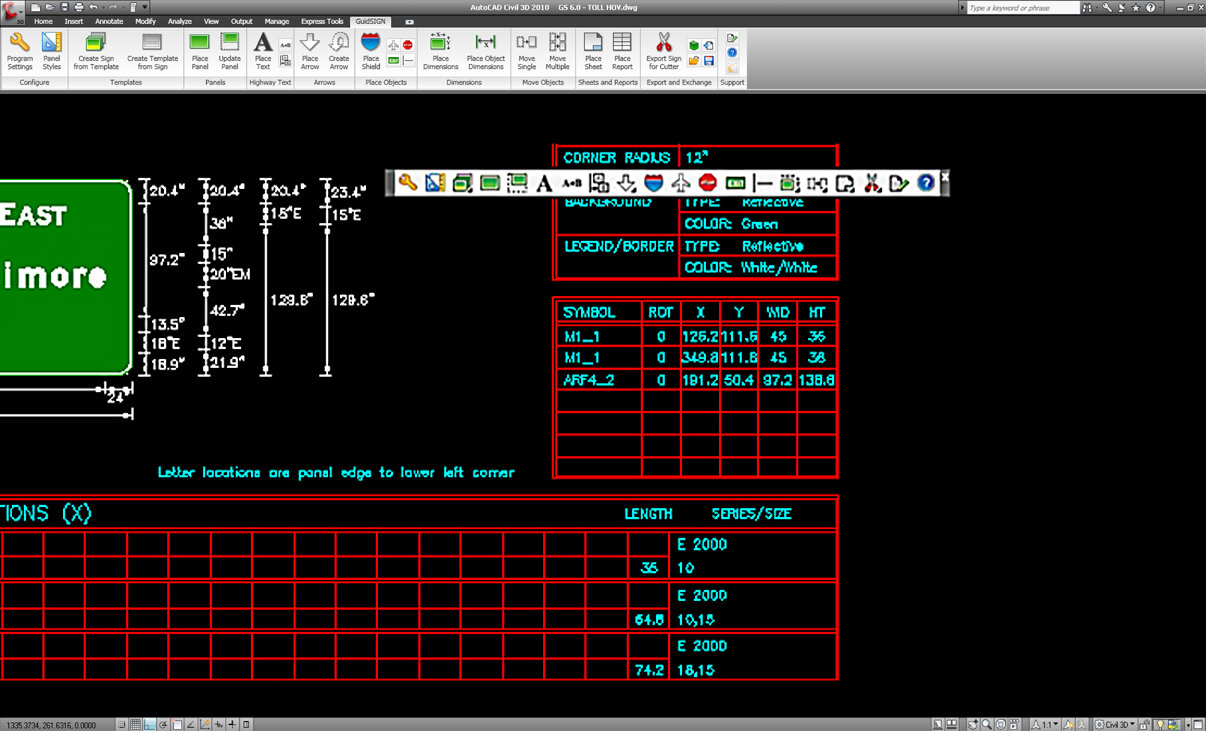
Point-to-point snap allows users to choose key points on fixed objects to accurately position the object being moved. Multiple objects can also be selected and centered between a vertical short line and a border within a panel.
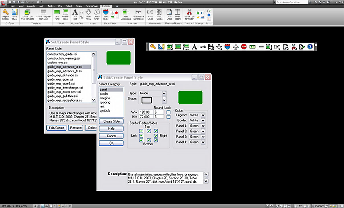
Modify Panel Styles
You can quickly and efficiently create and modify custom sign panels to fit strict project requirements. An extensive library of the latest national MUTCD panel styles combined with font flexibility in GuideSIGN Plus allows you to develop the exact signage required.
Align Text Components in a Panel
Pick a text component of a multi-part string to be positioned in reference to another text string sitting above or below. This saves from having to manually adjust each line to fit properly.
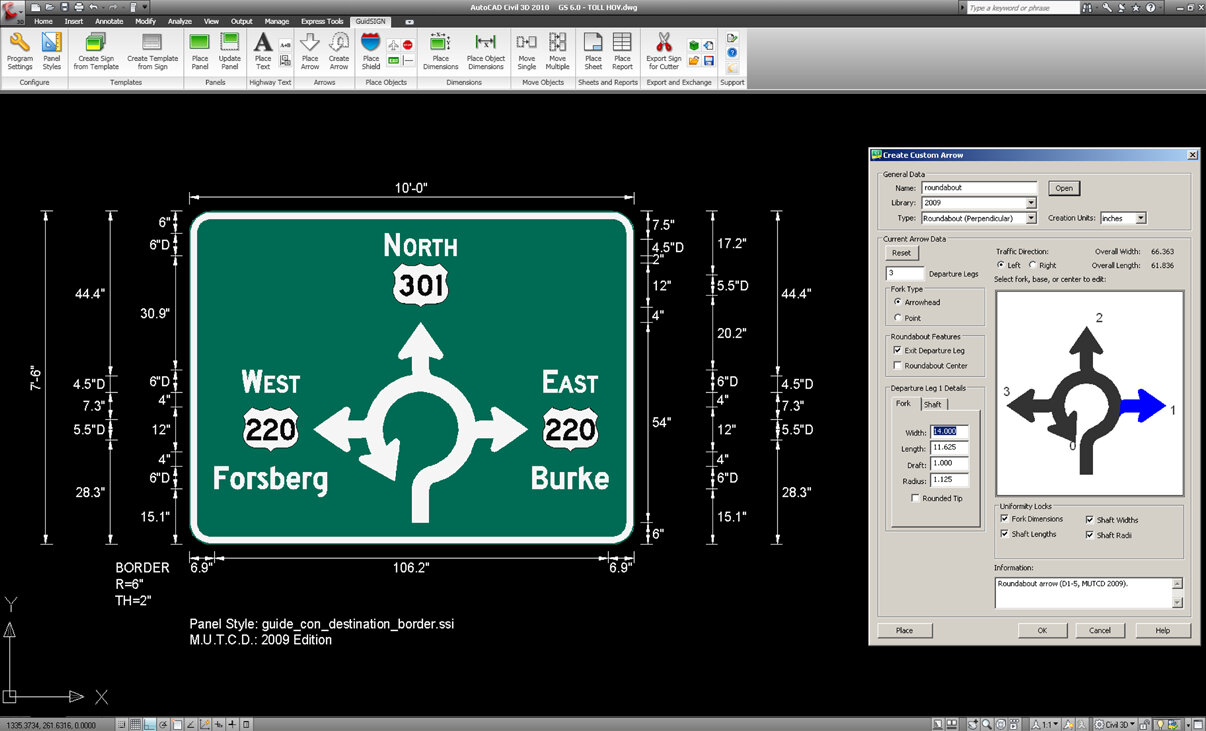
Custom Arrows
Need an arrow meeting requirements for a specific region or a unique project? User-defined directional arrows (straight, down, 45°- 90° turns, and custom types) can be designed with filleted bends and end points. Arrow types such as multi-headed diagrammatic for roundabouts, thru-turn, split and left-thru-right directions.
Build Template from Sign
After you have designed your sign, you can save to a library and then later select it to become your regular sign template for traffic signing plans (block or cell). No more having to recreate your signs from scratch.
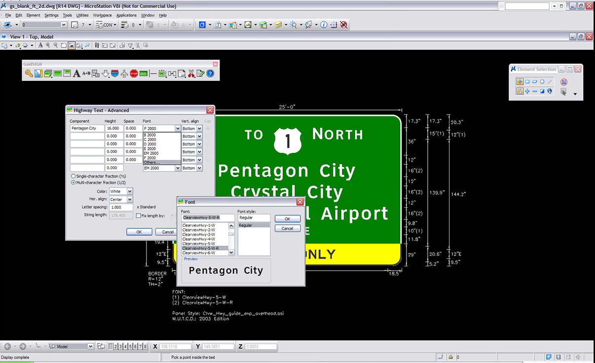
Font Selection
Designers can produce signage to meet any font requirements because GuideSIGN supports the FHWA standard typeface family, the ClearviewHwy® font system, and all true type fonts.
Language Accents
Handle French and Spanish accents – suitable for relevant place names (e.g. Quebec, Latin America, and some parts in the US).
Report Sign Fabrication
You can create comprehensive reports outlining all the signage details including schedules or facilitate database schema suitable for importing directly into existing asset management software.
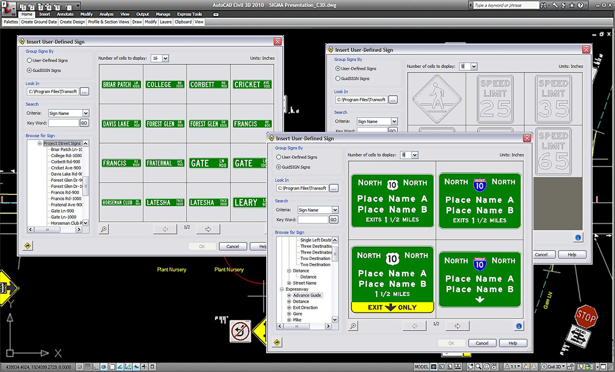
Sign Assembly
Work with your previously generated GuideSIGN signs or simple CAD drafted cell or block libraries. You can browse through your user-defined libraries and select signs for assembly design.

Additional Federal and Regional Signs
Additional sign libraries can be purchased to supplement your traffic sign planning projects. These high quality CAD sign libraries support full color, black & white filled, and outline display modes.
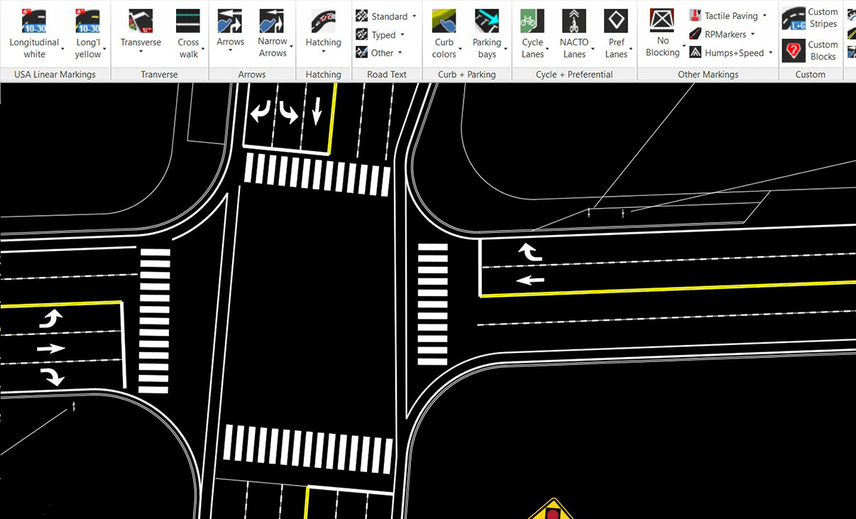
MUTCD Pavement Lines, Symbols, Numbers & Letters
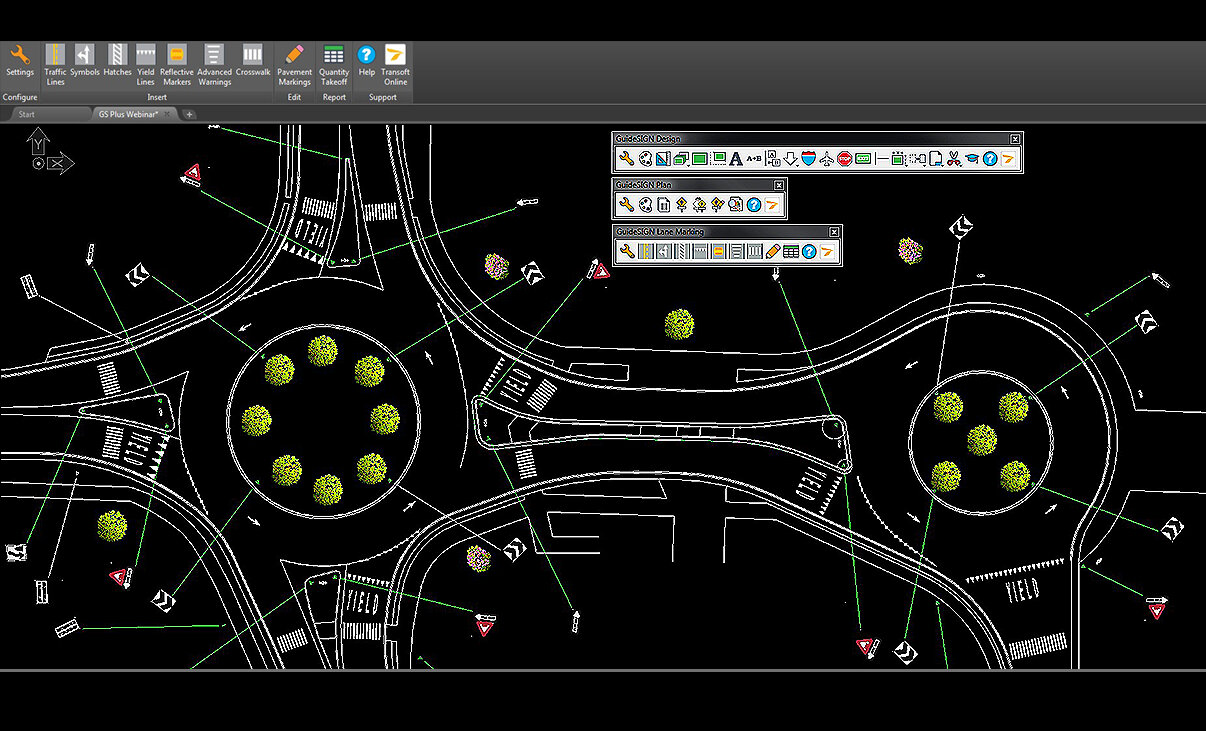
Easily add in any lines, arrows, hatches, symbol, number, or letters in accordance to MUTCD standard, onto your road design. Furthermore, you can custom build line types and dynamically edit objects. All markings associated with bus lanes, bus stops, cycle lanes or cycle facilities can be drawn to help with green transport strategies.
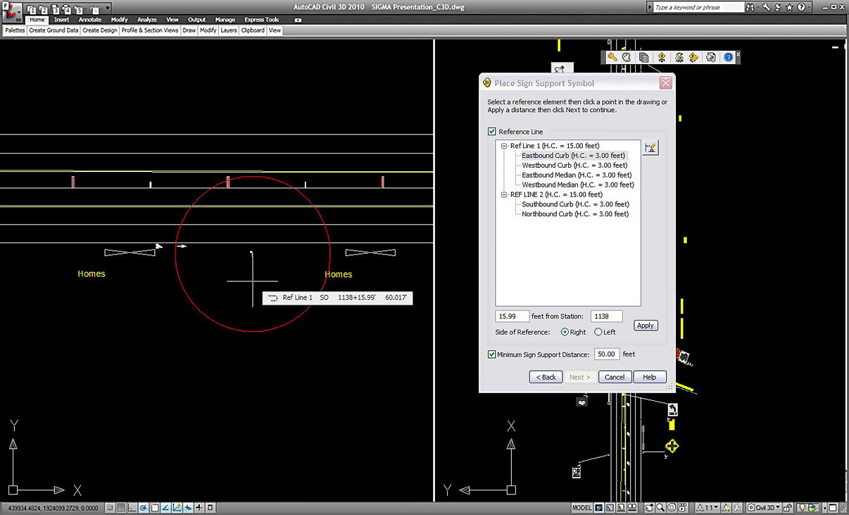
Sign Assembly Placement and Position
Place sign assemblies freely in your traffic plan drawing or in relation to a reference line. Offset reference geometry representing elements such as the edge of pavement, median, or shoulder, can be selected and set. GuideSIGN SIGMA supports simple geometry in base CAD platforms and stationing alignments in vertical CAD products.

Sign Plan Smart Templates
A unique feature that allows for placing multiple signs in a sign plan based on pre-set geometry and standards. Just select one of our premade templates and follow the simple steps shown on a preview, like picking your edge of a Road and Stop line to automatically create the required signs at the right distances to each other.
Pavement Markings
Draw a full range of pavement marking objects from rules and manuals – for rural and urban areas, easily adjust and match your road geometry. Items such as dotted lines to crosswalks can be created quickly, and can be edited by grip points and change values to meet any geometry.
Sign Assembly and Display Options
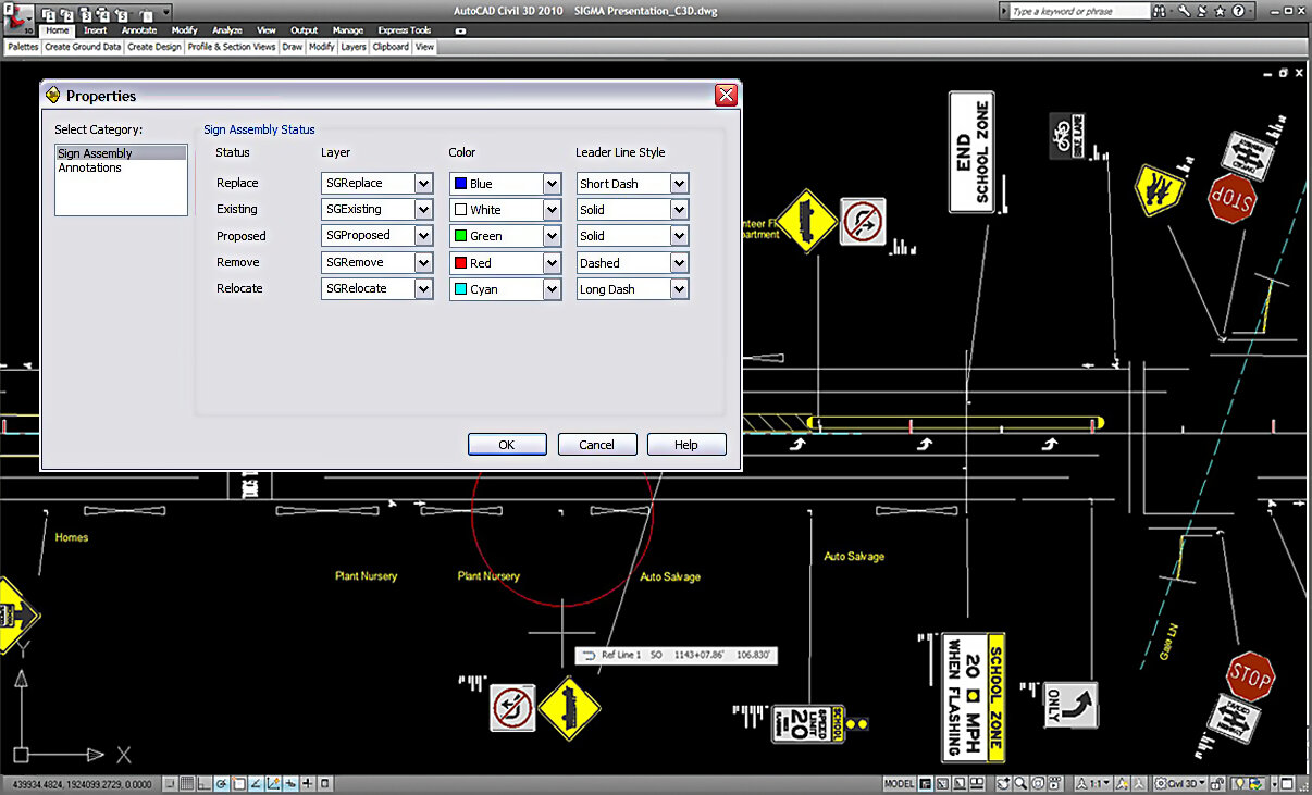
Easily change the status of an existing sign assembly and sign sizing, or add, remove or switch signs and sign groups within the defined assembly. Ensure a consistent visual display of placed sign assemblies in your traffic plan drawings. Each sign assembly status type can be placed on a unique level/layer and set with different color and line type.
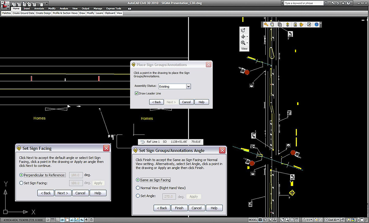
Adjust Sign Groups in Drawing
Set the sign support symbol rotation to orient the sign facing direction to match the direction of oncoming traffic. You can also add a leader line between the sign group and sign support symbol.
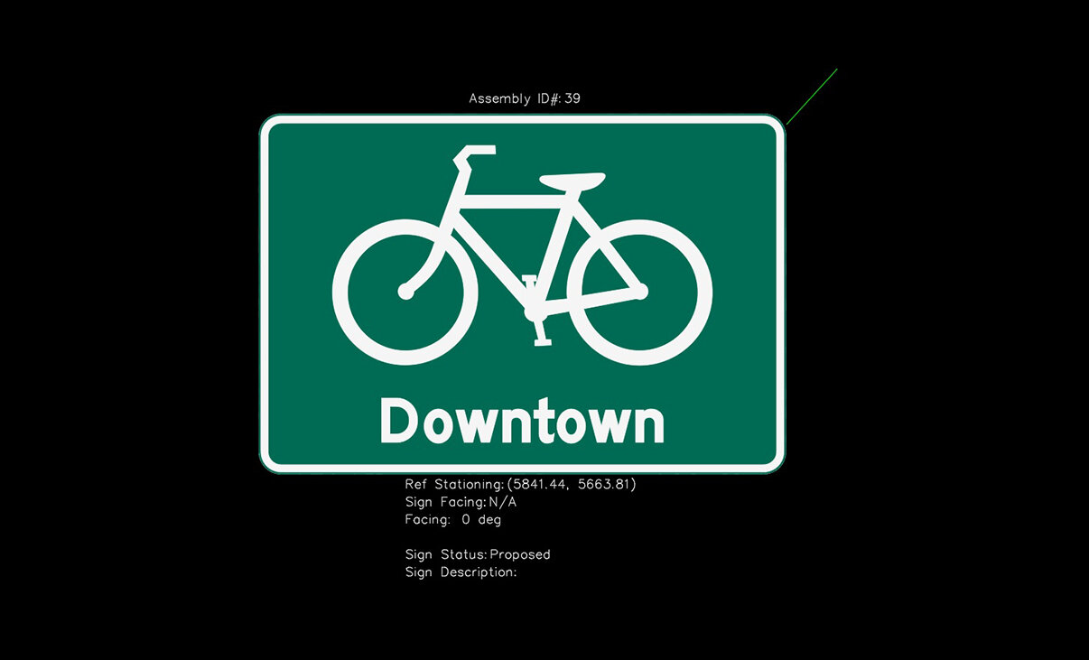
Customizable Sign Plan Annotations and Markers
A customizable and flexible annotation system for creating the labels on the sign facing is now available. Sign facings are created from complete and up-to date CAD libraries based on federal and state Guidelines – MUTCD and Supplements. Add sign name, sign description, sign status or sign material for example, save your customized Annotation Set and share it within your organization with an easy import and export function.
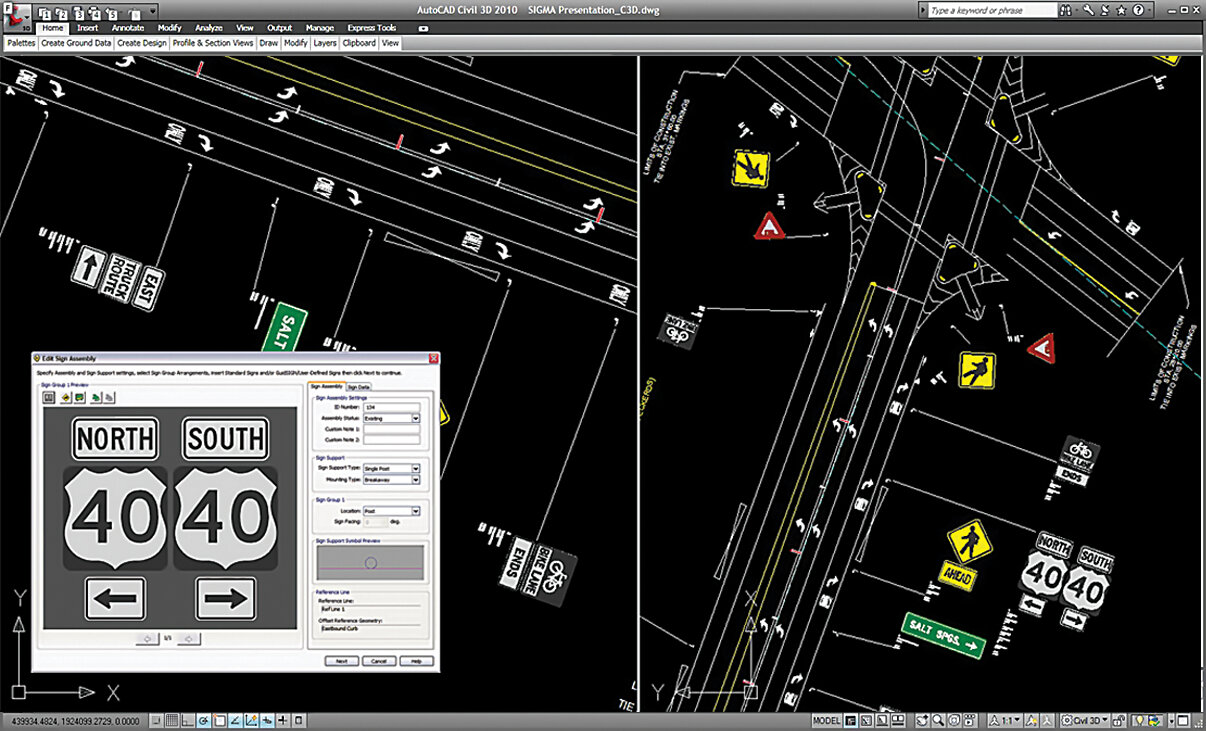
Dynamic Sign Assembly Creation
Select different sign arrangement templates to work with or create your own custom arrangement for sign assembles and set mounting types.
3D View
The powerful option to view your design in 3D not just helps with the design stages during safety audits, but also lets you get a better understanding and a realistic perspective of the impact on your road and intersection environment.
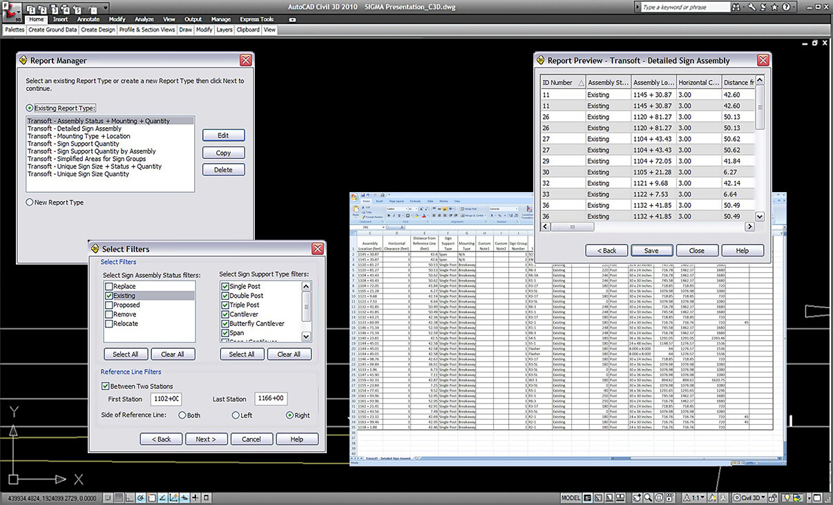
Sign Assembly Reporting
A flexible reporting solution allows you to create signage reports based on your required parameters. Reports can be saved in a CSV format and imported into common spreadsheet applications.
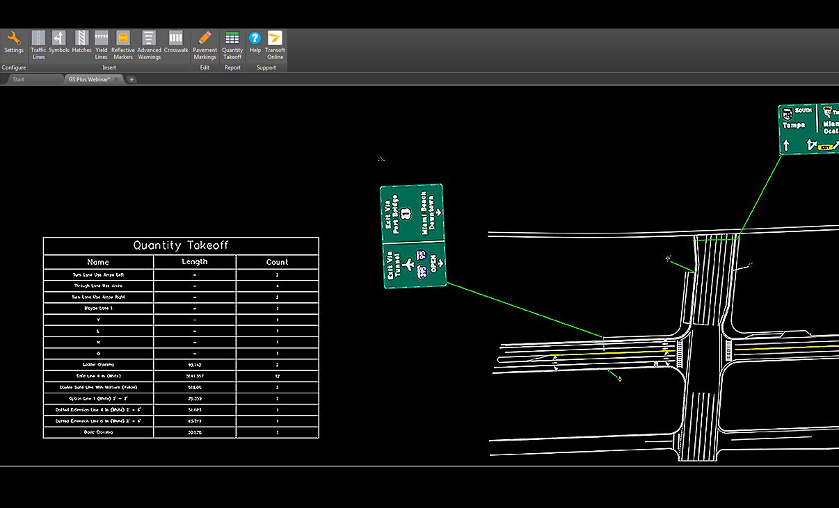
Pavement Marking Reporting
Automatically calculate and tabulate the quantities of each type of marking on a drawing and even provide a cost estimate, saving hours over manual calculation methods. Reports can be saved in a CSV format and imported into common spreadsheet applications.
Create Signs
Sign creation made easy with built-in rules to design panels to national standards like shields, arrows, text and symbols, with the flexibility to make custom content. Design signs for various needs, such as highways and roundabouts.
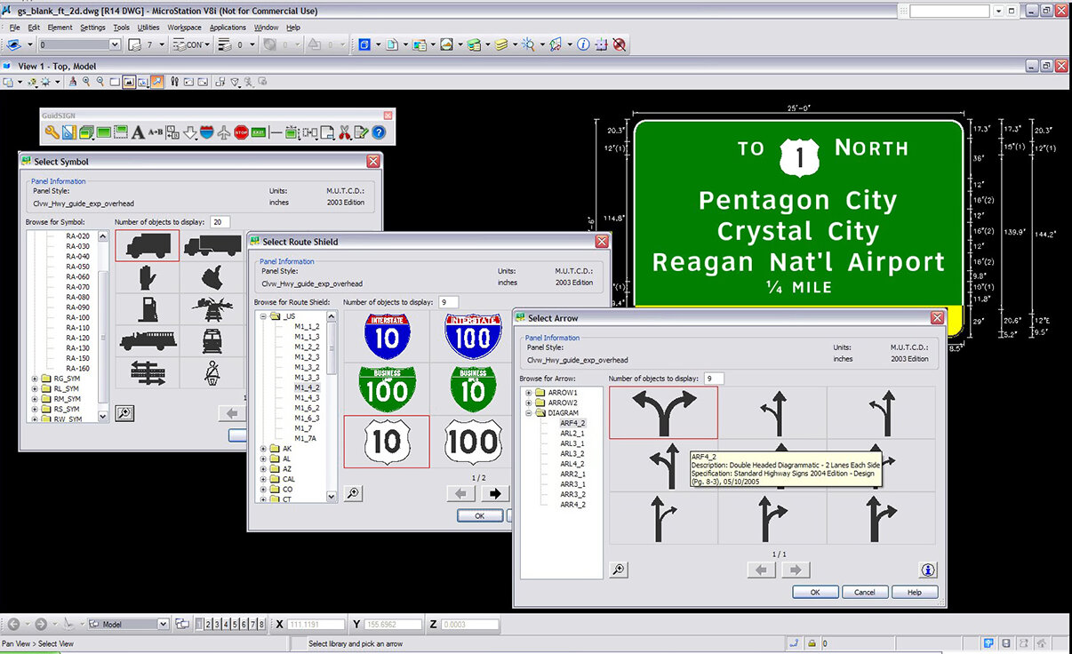
Panel Design
Easy and intuitive panel design. The program automatically re-dimensions dynamic panels as you add new elements. A sign can utilize design symbols from a library including multiple arrows, shields and even custom content.
Government and Agency Standards
GuideSIGN Plus supports the latest:
- US (MUTCD 2009 with all supplements)
- Canada (TAC-ATC 2001 with updates)
- Australia (AS 1744-2018)
Work with new color set, updated panel styles (for guide, street, exit, regulatory, warning, and construction), as well as updated libraries for route markers, shields, arrows, and symbols.
Create Signs From Template or Your Own
Design with consistency using guide or street signs from MUTCD standard or your own custom templates. Create a new sign by simply replacing text and available objects (shields, symbols, etc) within the panel. Together with current US (MUTCD 2009 with all supplements), Canada (TAC-ATC 2001 with updates) and Australia (AS 1744-2018)it provides you with over 200 new sign templates created specifically for the new guidelines.
Multiple Street Sign Design
Create multiple street signs in a single operation from a selected template and list of street names, street types, sections of the city, ordinal endings, and block numbers.
Sign Assembly
Work with your previously generated GuideSIGN signs or simple CAD drafted cell or block libraries. You can browse through your user-defined libraries and select signs for assembly design.
Additional Federal and Regional Signs
Additional sign libraries can be purchased to supplement your traffic sign planning projects. These high quality CAD sign libraries support full color, black & white filled, and outline display modes.
MUTCD Pavement Lines, Symbols, Numbers & Letters
Easily add in any lines, arrows, hatches, symbol, number, or letters in accordance to MUTCD standard, onto your road design. Furthermore, you can custom build line types and dynamically edit objects. All markings associated with bus lanes, bus stops, cycle lanes or cycle facilities can be drawn to help with green transport strategies.
Sign Assembly Placement and Position
Place sign assemblies freely in your traffic plan drawing or in relation to a reference line. Offset reference geometry representing elements such as the edge of pavement, median, or shoulder, can be selected and set. GuideSIGN SIGMA supports simple geometry in base CAD platforms and stationing alignments in vertical CAD products.
Sign Plan Smart Templates
A unique feature that allows for placing multiple signs in a sign plan based on pre-set geometry and standards. Just select one of our premade templates and follow the simple steps shown on a preview, like picking your edge of a Road and Stop line to automatically create the required signs at the right distances to each other.
Moving and Placing Objects in Panel
Point-to-point snap allows users to choose key points on fixed objects to accurately position the object being moved. Multiple objects can also be selected and centered between a vertical short line and a border within a panel.
Modify Panel Styles
You can quickly and efficiently create and modify custom sign panels to fit strict project requirements. An extensive library of the latest national MUTCD panel styles combined with font flexibility in GuideSIGN Plus allows you to develop the exact signage required.
Align Text Components in a Panel
Pick a text component of a multi-part string to be positioned in reference to another text string sitting above or below. This saves from having to manually adjust each line to fit properly.
Pavement Markings
Draw a full range of pavement marking objects from rules and manuals – for rural and urban areas, easily adjust and match your road geometry. Items such as dotted lines to crosswalks can be created quickly, and can be edited by grip points and change values to meet any geometry.
Sign Assembly and Display Options
Easily change the status of an existing sign assembly and sign sizing, or add, remove or switch signs and sign groups within the defined assembly. Ensure a consistent visual display of placed sign assemblies in your traffic plan drawings. Each sign assembly status type can be placed on a unique level/layer and set with different color and line type.
Adjust Sign Groups in Drawing
Set the sign support symbol rotation to orient the sign facing direction to match the direction of oncoming traffic. You can also add a leader line between the sign group and sign support symbol.
Custom Arrows
Need an arrow meeting requirements for a specific region or a unique project? User-defined directional arrows (straight, down, 45°- 90° turns, and custom types) can be designed with filleted bends and end points. Arrow types such as multi-headed diagrammatic for roundabouts, thru-turn, split and left-thru-right directions.
Build Template From Sign
After you have designed your sign, you can save to a library and then later select it to become your regular sign template for traffic signing plans (block or cell). No more having to recreate your signs from scratch.
Font Selection
Designers can produce signage to meet any font requirements with the FHWA standard typeface family, the ClearviewHwy® font system, and all true type fonts.
Language Accents
Handle French and Spanish accents – suitable for relevant place names (e.g. Quebec, Latin America, and some parts in the US).
Customizable Sign Plan Annotations and Markers
A customizable and flexible annotation system for creating the labels on the sign facing is now available. Sign facings are created from complete and up-to date CAD libraries based on federal and state Guidelines – MUTCD and Supplements. Add sign name, sign description, sign status or sign material for example, save your customized Annotation Set and share it within your organization with an easy import and export function.
Dynamic Sign Assembly Creation
Select different sign arrangement templates to work with or create your own custom arrangement for sign assembles and set mounting types.
Report Sign Fabrication
You can create comprehensive reports outlining all the signage details including schedules or facilitate database schema suitable for importing directly into existing asset management software.
3D View
The powerful option to view your design in 3D not just helps with the design stages during safety audits, but also lets you get a better understanding and a realistic perspective of the impact on your road and intersection environment.
Sign Assembly Reporting
A flexible reporting solution allows you to create signage reports based on your required parameters. Reports can be saved in a CSV format and imported into common spreadsheet applications.
Pavement Marking Reporting
Automatically calculate and tabulate the quantities of each type of marking on a drawing and even provide a cost estimate, saving hours over manual calculation methods. Reports can be saved in a CSV format and imported into common spreadsheet applications.
What’s New in GuideSIGN
New features, fixes, and other improvements built specifically with your feedback.
Updates and Improvements
GuideSIGN (Sign Design)
- New standard signs for the US region (MUTCD 2009 Guide, regulatory, school, and warning signs, as well as California 2023 signs).
- New standard signs for Canada (Based on TAC-ATC 2021).
- Additional content for GuideSIGN sign design, parking panels, and California arrows.
- Even letter spaces option in the Highway Text – Advanced dialog box.
- Ability to set spacing for dividers using the Edit Panel Style dialog box.
- Ability to edit font style and font size using the Place Report tool.
- Ability to turn off the extra line at the panel’s edge in the Edit Panel Style dialog box.
GuideSIGN Sigma (Sign Plan)
- Additional Standard Sign Plan libraries for Victoria 2017 (Australia), New Zealand 2023, California 2023 (US), and Ontario 2022 (Canada).
GuideSIGN Plus: All of the above
Bug Fixes
GuideSIGN (Sign Design)
- Fixed DXF files that are created with the Export Sign for Cutter function and the separate files option to list consistent names and correct colors.
- Fixed the Transoft Online button on the Toolbar or Ribbon to point to the correct web location.
- Improved the Override Panel Style Borders function in the Update Existing Panel dialog box.
- Improved the support for True Type fonts when placing text using GuideSIGN.
- Improved the Highway Text – Advanced dialog box options for spacing letters and adjusting the word gap.
- Fixed the Name X Units, X Units, and Exit X Units text styles to include correct spacing.
- Improved the Create Custom Arrow tool to reduce distorted geometry.
GuideSIGN Sigma (Sign Plan)
- Fixed an issue where information entered in the Replacement Field boxes was not saved when creating sign assemblies.
- Fixed the sign assembly span length in span type assemblies to be correctly retained when editing sign assemblies.
- Added default annotations sets and corrected the folder location.
- Renamed “Vertical Clearance” to “Sign Height” and simplified adjusting vertical offset for post type structures.
- Changed the region name AUS to AUS & NZ to include New Zealand content.
- Fixed the alignment of 3D models for double post and triple post structures to ensure accurate centering in signs.
- Fixed an issue where creating Pavement Markings Reports caused crashes in OpenRoads Designer.
GuideSIGN Plus: All of the above
Compatibility for:
- Autodesk® AutoCAD® 2017 – 2024 (except AutoCAD LT)
- Autodesk® AutoCAD® Civil 3D® 2017 – 2024 alignments
- Bentley® MicroStation® V8i (SS10), CONNECT (Update 14+)
- Bentley® PowerDraft® V8i, CONNECT (Update 14+, not supported for Pavement Marking)
- Bentley® Power GEOPAK V8i, Power InRoads V8i, PowerCivil V8i
- Bentley® AECOsim Building Designer V8i, CONNECT
- Bentley® OpenBuildings Designer CONNECT
- Bentley® OpenRoads Designer CONNECT (Update 8+)
- Bricsys® BricsCAD® Pro V21 – V23 (Pavement Marking tools are not supported on BricsCAD)
5 new sign libraries
- Arizona 2019
- Ohio 2021
- Indiana 2011
- Missouri 2019
- Montana 2022
Compatibility for Bricsys® BricsCAD® Pro V21 – V23
Bug fixes
- Fixed TTF fonts
- Added an Apply button into the Place Object and Move Object dialog boxes for Bentley platform users
- Fixed file names for the ‘In Separate Files’ option within the export to DXF feature
- Minor content corrections
More editing options for your sign panel designs:
- Place text and objects based on the edge of the panel
- Override Panel Style borders option when updating a panel, allowing the changing of borders radius, inset and thickness
- Edit the panel width, height and corners from square to rounded without the need to create a custom panel
Improvements to the accent tool, allowing editing of text to include French or Spanish accents as part of place names
Updated Content for panel styles, shields, arrows, symbols and standard signs:
- Canada (TAC-ATC 2021)
- Australia (AS 1743-2018)
Bug Fixes
- fixed grayed out Table tags and text size errors in Microstation Connect
- Select custom arrows from a library list
- Place New Panel in MicroStation Connect and ORD
- Improved TTF display
- Restored place highway text
- .dxf file can now open in AutoCAD platform v8i, Connect and ORD
- Fixed scaling for sheets and reports
- Loading errors corrected
- Corrected color change of TTF font on Edit Highway Text for MSTN Connect
- Corrected Export Sign to Cutter feature to use the correct layer/level
- Relocation of Sign folder files from Common\Source to GuideSIGN repository
- Corrected MSTN Connect display issues after placing objects into the panel
- Text errors in Place Shield corrected
- Resolved Accent preview error
- Corrected setting color for dimensions for MicroStation
- Fixed truncated units for Place Short Line and Highway Text
- Updated spacing for Highway Text – Advanced: Text, Height, or Space using region specific tables
- Corrected descenders display issues for accents
- Corrected accent height and spacing
- Corrected space between two strings for Edit Highway Text
- Corrected CAN region text display for Place Highway Text
- Fixed display of “Number of Sign Library” text
- Fixed unit display for Create Custom Arrow
- Display dimensions of arrows on black background for Create Arrow
- Updated spacing for words and letters for different regions
More templates for the Smart Sign Plan Template feature:
- Curve of road
- Exit ramps
- Temporary Traffic Control
- And more!
Improved 3D graphics using mesh technology – making it easier to transfer them to other 3D modelling software
Optionally add in surfaces or terrain models to view sign assemblies with base elevations
New options to select a surface or terrain to place assemblies from template, a new feature to place groups of sign assemblies, and a new feature to use Open Roads or Civil 3D alignments in a template, along with improvements to stationing and offsets
Specify elevation for each individual post for the span support type
Improvements to the steps to place sign assemblies, particularly the ability to use separate elevations for the bases of each side of a span, or to set precise distances from posts for placing signs along a span.
Improved multiple sign placement & positioning on a post
Add in horizontal distances from post
Display Signs in 2D or 3D for detailed visualization, such as vertical clearance for larger sized vehicles and other obstacles or examine the interaction between the different elements
Draping 3D surfaces and 3D street furniture for pavement marking in Bentley products
Collaborate & coordinate better with project and design partners by exporting your 3D sign structure and pavement marking to IFC, BIM, SHP or CSV, or customize the design data. Check for clashes and provide details of materials for costings and future maintenance.
New additions to the Sign Library
- Canada TAC 2021
- Australia AS 1743 2018
Bug Fixes
- Resolved Horizontal clearance for place sign support symbol
- Corrected place standard sign size for AutoCAD * MSTNv8i
- Icon file (.ico) added back into Program Files folder
- 2D crashes for Microstation
- Larger pop-up window for place sign support symbol
- Repaired report manager crash
- Fixed alignment for FDOT sheets and reports
All of GuideSIGN and GuideSIGN Sigma combined
Bug Fixes
- Fixed slow operation of GuideSIGN Plan in MicroStation CONNECT/ORD
- Loads GuideSIGN Design and Plan in Microstation Connect and ORD
- Fixed custom sign facing size during placing user defined signs in 2D
- Resolved “fatal error” for sign assembly with sign support type as “Structure”
Licensing Options
Transoft offers a range of licensing options to help small, sole proprietorships right on up to the largest multinational organizations meet their transportation design and analysis needs.
User Subscription License (USL) is a model where a set number of Subscribed Users are assigned dedicated access to the software through their unique logins for the duration of the license term. The software can be installed and used by a Subscribed User on multiple workstations.
Each Subscribed User represents one individual and their login and password, which cannot be shared with other users. Software activation is an easy process and can be done over the Internet.
Why Choose the USL Option
User Subscription License offers a cost-effective way for small businesses to start with one user and grow by adding additional users. For larger organizations, it will offer more flexibility in user administration and management via the My Transoft Portal. Furthermore, it can easily handle scalability and budgeting as per the business needs defined by the number of users.
Key Benefits of USL License
- Automatic updates, new features, and content
Bug fixes, compatibility, and new version releases. - Easily manage your changing business needs
With enhanced scalability and user management. - Install the software and log in from anywhere
Access your workstation, laptop, or personal desktop. - Unlimited technical support
Receive premium assistance for all your deployments and technical support needs. - Invitations to learning-focused webinars
Attend learning-focused webinars from our product experts and learn how our software can help streamline design processes. - Flexible user license options
Choose from single to multiple user packages to meet your business needs. - Simple user administration
User Management can be performed in the My Transoft Portal, via invitation links or by Identity Provider Single Sign-on with User Provisioning.
Have more questions about USL? See the FAQ here.
Team Subscription License (TSL) is a license option that is intended to support casual or occasional users of the software. The size of a TSL is represented as a number of allocatable seats.
Why Choose the TSL Option
While User Subscription Licenses are better for dedicated users, Team Subscription Licenses can be a good complement to these if your organization has occasional, less heavy users of the software.
How it Works
Each user of a TSL must have an account in the My Transoft Portal to request a license. Internet access is required for this process.
When an end user starts the software product on their workstation, the software will connect to the My Transoft Portal and will determine if any of the seats are available. If a seat is available, it will be allocated and dedicated to that end user who will have unrestricted access to it for 24 hours. At the end of the 24-hour period the seat allocation will automatically expire, and another user will be able to claim it.
Once all the TSL seats are allocated at a given time, no other end user will be able to use that license until the 24-hour period expires and one of the seats is automatically deallocated.
Key Benefits of TSL
- More flexibility for your team members
Allows access to software for casual users without having to spend on dedicated licenses for all users. - Less administrative effort by IT
Easy access to software for casual users without IT having to allocate or transfer licenses amongst team members, self-administered by users with automatic 24-hour lock. - Combined Team & User Subscription option
Flexibility of mixing plans according to the needs of different user types. - Automatic updates, new features, and content
Bug fixes, compatibility, new version releases, or vehicle guidelines are automatically available to you. - Easily manage your changing business needs
With enhanced scalability and user management. - Install the software and log in from anywhere
Access your workstation, laptop, or personal desktop with Single Sign-on. - Unlimited technical support
Receive premium assistance for all your deployments and technical support needs. - Invitations to learning-focused webinars
Attend learning-focused webinars from our product experts and learn how our software can help streamline design processes. - Simple user administration
User Management can be performed in the My Transoft Portal, via invitation links or by Identity Provider Single Sign-on with User Provisioning.
Transoft Support
We take pride in delivering complete customer satisfaction. Get help with products, downloads, technical support, and more.
My Transoft Portal
Transoft's product enhancements are periodically released to provide access to new features, fixes, and security updates. For many products, you can find these updates and download them directly from My Transoft Portal.
Software License Agreement
For information on terms and conditions detailing the usage of our software, please refer to Transoft’s Software License Agreement (SLA).
Software FAQ
Search our extensive product knowledgebase that address some of the most frequently asked questions regarding Transoft ‘s software.
Help Desk
Find answers to your issues on a variety of topics or request Technical Support. Get help with downloading and installing your software, managing your account, product compatibility and much more.
Licensing Options
Transoft offers a range of licensing options to help small, sole proprietorships right on up to the largest multinational organizations meet their transportation design and analysis needs.
Project Support Services
Need assistance with custom drawings and content creation related to your project design work? Transoft’s team of consultants can help. We deliver fast and helpful services for clients requesting additional assistance with drawings and simulations related to their project design work.
Compare
Three modules to choose from: sign design, sign planning and pavement marking, or all of the above. Each with its own features that provide a tailored solution enhancing your workflow and taking your productivity further.
| GuideSIGN Plus |
GuideSIGN SIGMA | GuideSIGN | |
| Sign Design | |||
| Easily create custom signs for highways, freeways, city roads, and more | ✓ | ✓ | |
| Find an up-to-date list of State MUTCD objects | ✓ | ✓ | |
| Edit signs from existing built-in templates | ✓ | ✓ | |
| Create alternative signs such as parking, garbage, bicycle and recycling signs | ✓ | ✓ | |
| Sign Planning | |||
| Full traffic sign libraries for city roads, highways, freeways, temporary construction and more |
✓ | ✓ | |
| Automatically place multiple signs based on pre-set geometry and standards in a plan |
✓ | ✓ | |
| Pavement Marking | |||
| Place pavement markings based on federal and state specific standards | ✓ | ✓ | |
| Island Hatches, Yield Lines, Reflective Markers, Advanced Warning Symbols & Crosswalks |
✓ | ✓ | |
| Draw and edit continuous dashed lines, hatches and arrows | ✓ | ✓ | |
| 2D and 3D Views | |||
| 2D and 3D view to see interaction between the road and the sign’s vertical clearance | ✓ | ✓ | |
| Add 3D street furniture | ✓ | ✓ | |
| Exporting | |||
| Export signs for cutter and print shop | ✓ | ✓ | |
| Reporting | |||
| Quantity take-off reports for cost estimates | ✓ | ✓ | |
| Export data to IFC, BIM, SHP and CSV | ✓ | ✓ | |
| Detailed sign assembly mounting and quantity reports | ✓ | ✓ | |
| Fabrication and panel reports | ✓ | ✓ |
Training
We offer many excellent opportunities for you to take a more interactive approach in learning about our solutions. From webinars to how to videos, find what you need here.
GuideSIGN Videos
Request a Quote
Thank you for your interest in GuideSIGN. Fill out the form to receive information on purchasing and licensing options or if you have questions in general about the software.
On business days, you can expect a response within 24 hours of your request.